


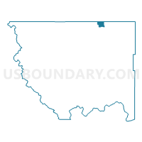
Eder Voting District, Okanogan County, Washington
About
Outline

Summary
| Unique Area Identifier | 687819 |
| Name | Eder Voting District |
| County | Okanogan County |
| State | Washington |
| Area (square miles) | 15.17 |
| Land Area (square miles) | 13.95 |
| Water Area (square miles) | 1.23 |
| % of Land Area | 91.90 |
| % of Water Area | 8.10 |
| Latitude of the Internal Point | 48.98803450 |
| Longtitude of the Internal Point | -119.38410680 |
Maps


Graphs
Select a template below for downloading or customizing gragh for Eder Voting District, Okanogan County, Washington


Neighbors
Neighoring Voting District (by Name) Neighboring Voting District on the Map
- Boundary Voting District, Okanogan County, WA
- Eastlake Voting District, Okanogan County, WA
- Molson Voting District, Okanogan County, WA
- Tonasket Creek Voting District, Okanogan County, WA